
Trip planning · Weather
Los Cabos Hurricane Season
The season runs May 15 to November 30, and most of it passes with nothing at all. Here is the live picture, month by month, and what a storm actually closes here.
Live right now2 active storms
NOAA National Hurricane Center
Right now
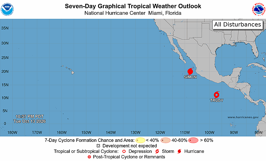
What the hurricane center is watching
A named storm is only half the picture. Before anything gets a name it is an area of disturbed weather, and the National Hurricane Center publishes where those areas are and how likely each one is to develop. This is that map, straight from the NHC.
The calendar
When the season runs, and when it actually matters
The eastern Pacific hurricane season officially opens on May 15 and closes on November 30. Activity peaks in late August, and most tropical cyclones in the basin form between late June and early October.
A typical season produces about 15 named storms, 8 hurricanes and 4 major hurricanes across the whole eastern Pacific basin, based on the 1991–2020 averages. That number sounds alarming until you look at where those storms go: the overwhelming majority spin west into open ocean and never come near land. The Baja peninsula sits at the northern edge of the basin, and only a small fraction of storms track far enough north to reach it.
The practical translation: hurricane season is not a season of hurricanes in Los Cabos. It is a season during which you check the forecast before you fly, the same way you would for a Caribbean or Florida trip.
Why this stretch of ocean can build them
Tropical systems need sea temperatures above roughly 26.5 °C to strengthen. Here is where the water sits today on the three coasts of Los Cabos — the same reading that makes the swimming so good in these months.
Every coast is above the 26.5°C line right now — that is why this basin can build hurricanes, and also why the swimming is so good. Live from Open-Meteo Marine (weather data by Open-Meteo.com, CC BY 4.0). Source for the threshold: NOAA NHC.
The shape of the risk
Month by month
Recorded tropical cyclone impacts on the Baja California peninsula, by month. September is not slightly worse than the rest — it accounts for more than every other month combined.
Counts cover the entire Baja California peninsula across the historical record, not landfalls on Los Cabos specifically, which are rarer still. Treat them as the shape of the risk, not as odds for your week.
And your week specifically
That chart describes the season. This one answers the actual question: of the seasons on record, how many had a storm near Los Cabos during the exact week you arrive.
5.3%Arriving October 13, 5.3% of the last 75 seasons had a tropical storm or stronger pass within 200 km of Los Cabos during those seven days. For a hurricane specifically: 2.7%.
Counted from the NOAA HURDAT2 archive, 75 seasons (1949–2023), using rolling seven-day windows from each arrival date. History is not a forecast — for what is happening now, read the live panel at the top of this page.
On the ground
What a storm actually changes here
Distance in kilometres is not what decides your day. These four things are.
Ports openCabo San Lucas and San José del Cabo · stamped Oct 13, 7:36 AMSEMAR
Planning
Should you book during hurricane season?
Plenty of people do, deliberately. August through early October is the cheapest stretch of the year here, the sea is at its warmest, and the odds that any specific week gets disrupted are low. The trick is booking so that a bad week costs you nothing.
- Book refundable rates. The premium over a non-refundable rate is small next to the price of a forfeited week. This is the single most useful thing you can do.
- Buy travel insurance that names hurricanes. Read what actually triggers a payout: many policies only pay if your resort is uninhabitable or the airport formally closes, and none will sell you cover once a storm is already named.
- Ask charters and tour operators their storm policy before you pay. The good ones reschedule or refund without an argument. Get it in writing.
- Start watching about seven days out. Earlier than that, forecasts cannot tell you much. The live panel on this page is the quick version.
- If you have one non-negotiable plan — a wedding, a fishing tournament, a proposal on a boat — think twice about the second week of September.
Already in Cabo
If a storm is coming while you are here
- Do what your hotel tells you. Resorts here have hurricane protocol and they run it properly. They have done this before.
- Follow the NHC for the forecast and Protección Civil BCS for local orders. Not social media.
- Contact your airline early. Most waive change fees once a storm is named, and seats go fast.
- Fill water bottles, charge everything, draw cash. Card terminals go down with the power.
- Stay off the water and away from arroyos. Flash flooding in the dry riverbeds kills more people here than wind does.
The worst case on record
Hurricane Odile, 2014
Odile is the storm people mean when they ask whether Cabo is safe. It is worth knowing exactly what happened, because it is the worst case on record and it is still the exception, not the pattern.
- Olivia 1967peak 204 km/h
- Kiko 1989peak 194 km/h
- Odile 2014peak 222 km/h
Odile made landfall near Cabo San Lucas as a Category 3 hurricane — the first major hurricane to directly hit the Baja California peninsula in 25 years, and the most destructive on record for the area. Some 239,000 utility customers lost power and water, in places for two weeks. Los Cabos International closed to commercial traffic and officials estimated ten days to fully reopen; tourists were flown out on government aircraft in the meantime. The NHC report attributes at least 15 deaths to the storm.
The rebuild was fast and, in most of the hotel zone, complete within a couple of years. Only three major hurricanes have made landfall in Baja California Sur since 1948: Olivia in 1967, Kiko in 1989 and Odile in 2014.
Straight answers
Common questions
Is it safe to travel to Los Cabos during hurricane season?
Yes, with normal precautions. Most of the season passes without any storm reaching the peninsula, resorts have well-rehearsed protocols, and modern forecasting gives several days of warning. Book refundable rates and watch the forecast in the week before you fly.
What is the worst month for hurricanes in Los Cabos?
September, clearly. It accounts for more recorded tropical cyclone impacts on the Baja peninsula than all other months combined. August and October are the next most active.
Will it rain the whole time?
No. Even in September, rain in Los Cabos usually arrives as short, heavy bursts rather than all-day drizzle. The region is a desert; annual rainfall is measured in a handful of inches, most of it falling in these months.
What happens to my fishing charter or boat tour if a storm is near?
If the Captain of the Port closes the harbour, nothing sails, regardless of the weather where you are standing. Ask your operator before booking whether they reschedule or refund in that situation.
How much warning do you get?
Usually several days for a system that might approach, and a fairly confident picture two to three days out. That is normally enough time to change a flight.
Does the ocean stay warm during hurricane season?
It is the warmest stretch of the year, generally in the high 20s Celsius (low 80s Fahrenheit), which is exactly why storms can strengthen here.
When is the cheapest time to visit Los Cabos?
Late August through September, which is exactly the peak of hurricane season. That is the trade-off: the lowest rates of the year in exchange for the highest chance of a disrupted day.
Sources: NOAA National Hurricane Center — Tropical Cyclone Climatology · NHC Tropical Cyclone Report: Hurricane Odile (EP152014) · NHC live storm data. The live panel refreshes automatically from the NHC CurrentStorms feed. Seasonal impact counts are compiled from the historical record for the Baja California peninsula.
By the What’s In Cabo Editorial Team. Informational only — this is not an official weather product.